New for 2024, the Cotswold Riders Way is a long-distance mountain biking & horse riding trail created in partnership with Cotswold National Landscape and volunteers from the British Horse Society. This ‘free-to-access’ route is hoped to encourage more riders to explore and enjoy this nationally significant landscape in a sustainable way.
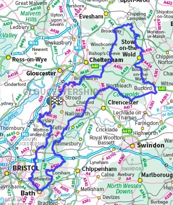
For mountain bikers, the Cotswold Riders Way offers a stunning 300km circular trail around the Cotswolds. The route links many of the iconic Cotswold landscapes and villages and gives riders a unique perspective on this Area of Outstanding Natural Beauty (AoNB). See route outline on map below.
The riding has an off-road bias with a focus on traffic-free bridleways and byways. Where possible, road sections have been limited to quiet country lanes and ‘B’ roads. The short sections on ‘A’ roads are mostly crossings.
The Cotswold Riders Way is not waymarked on the ground. A route map is available below via a free-of-charge digital download (gpx file). The file is suitable for loading on a navigation device eg Garmin or for viewing on mapping software eg OS Maps or Memory Map. The route is not available in paper format.
If digital maps and navigation aren’t for you, book a guided ride
Route type: Long Distance Circular